Curated OER
The Continents and Oceans of the World
Students explore world mapping skills. In this world geography lesson, students identify and label the continents and oceans on a world map using the Visual Thesaurus. Students generate mnemonic devices to help memorize these terms.
Curated OER
Leapin' Landmarks: Locating 10 Man-made Landmarks Around the World
Third graders label continents, oceans, and major mountain ranges on maps and use the maps to write an informational report about landmarks. In this landmarks lesson plan, 3rd graders write about 1 major landmark.
Curated OER
Continents
Students investigate World Geography by researching the different continents. In this Asian Geography lesson, students discuss the continent of Pangaea and color a worksheet of the continents. Students locate China on the map worksheet...
Curated OER
Learning European Geography
Sixth graders discover locations and countries in Europe by identifying them on a map. In this European geography lesson, 6th graders read the book The Lost Little Elephant, with their class and discuss the geography referenced in...
Curated OER
Antarctica Map
In this Antarctica worksheet, students study a very detailed map of this continent. Important features on this map are labeled.
Curated OER
Africa, A Look Through the Eyes of A Child
Second graders read literature about Africa, examine physical characteristics of the continent, explore animals native to Africa, and discuss distance between Africa and locations in the United States.
Curated OER
North American Biomes
In this Science worksheet, learners color a biome map of North America. Students color the map by solving the clues listed on a separate sheet of paper.
Curated OER
Antarctica
In this map worksheet, 3rd graders explore a map of the continent of Antarctica. Students will color and label the map of the continent.
Curated OER
Outline Map of Japan
In this geography instructional activity, students examine a black line outline map of Japan. There is a compass rose on the page. There are no labeled cities.
Curated OER
New: Around the World
First graders identify and demonstrate how symbols and models are used to represent features of the environment. They use a map and a globe to label where the students in the book came from, point out the continent, and show which ocean...
Curated OER
Put Me in My Place: Using Alphanumeric Grids to Locate Places
Learners practice locating points on a large wall grid and create and label a neighborhood map. In this geography lesson, students spell and discuss places as the teacher places them on the map. They discuss the concept of an...
Curated OER
Biome Map
In this biomes worksheet, learners color the map of North America according to the biome clues. Students then answer questions about the North American biomes.
Curated OER
If These Walls Could Talk: Seeing a Culture Through Human Features
Students read Talking Walls and discuss the walls presented and their importance to the culture. In this geography lesson, students locate and label each country/continent discussed in the book on a world map. Students take a walk and...
Curated OER
New Perspectives
Students examine maps that are designed to give different perspectives. They create mental maps that illustrate their own perspectives and those of people from other parts of the world.
Curated OER
Physical Geography of Africa
Fifth graders investigate the topography of Africa. In this physical geography lesson, 5th graders research the six regions of Africa and complete a physical map. Students locate various landforms in Africa. Students...
Curated OER
Middle East Related
Eighth graders find a current event related to the Middle East. In this current event lesson students write a brief summary of a new story related to the Middle East. They give their opinion and tell how it affects their life or who it...
Curated OER
Family Life in a Village in Bangladesh
In this Bangladesh learning exercise, students read about the lives of men and women and the weather in Bangladesh. They then take that information to create a poster. Maps are also provided.
Curated OER
The 50 States and its Holidays
Though the format of this ELL lesson is confusing (the standards listed are for plate tectonics, yet the objectives are for American geography and holidays), a teacher could glean some ideas from the main idea. Here, pupils complete a...
Curated OER
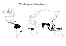
World Map With Rain Forests
In this geography worksheet, students study a map of the world which shows shaded areas indicating where the rain forests are located. There are no labels for countries or continents.
Curated OER
Learning About Our World
Young scholars explore their world using the book "This is the Way We Go to School." They predict information about the story based on the title and pictures. Students label a world map with the names of continents and oceans. They write...
Curated OER
Leapin' Landmarks: Locating 10 man-made landmarks around the world
Third graders engage in a lesson which addresses their curiosity about some of the outstanding people-made landmarks of the world. They explore the geographical themes of location and place through literature.
Curated OER
Fighting Disease
Seventh graders explore the concept of medical intervention in African nations. In this geography lesson, 7th graders research primary and secondary sources in search of information regarding Guinea worm disease. Students use their...
Curated OER
On the Road Again": Moving People, Products, and Ideas
In this lesson students learn how to identify modes of transportation and communication for moving people, products, and ideas from place to place. Students also study the advantages and disadvantages of different modes of...


