Curated OER
Designing a Hiking Trail
Put your students' map skills to the test with this engaging cross-curricular project. Given the task of developing new hiking trails for their local community, young cartographers must map out beginner and intermediate...
Curated OER
Topographic Maps
In this topographic map worksheet, students learn how to read a topographic map and create a topographic map of their own using clay or Play-Doh. Students include contour lines by layering the clay. Students answer 6 questions about...
Education Outside
Nature's Treasure Map
Youngsters construct a map of treasures that they find along a nature trail as they hike. They also make sketches and create place names of some of the spots along the trail. Once back in class, pupils use their treasure maps to help...
Curated OER
Mapping Ancient Coastlines
Most of this instructional activity is spent working on the "Bathymetry Worksheet." It includes a graph of the changes in sea level over the past 150,000 years and a bathymetric map of changes in an imaginary coastline over time....
Curated OER
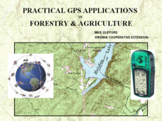
Practical GPS Applications in Forestry & Agriculture
An explanation of the Global Positioning System (GPS) and the Geographic Information System (GIS) is given in this presentation. Uses and applications are considered. How it works and sources of error are also touched upon. A large...
Curated OER
Weather Forecasting Unit
Learners study weather concepts, mapping, characteristics in this series of lessons.
Cornell University
Constructing and Visualizing Topographic Profiles
Militaries throughout history have used topography information to plan strategies, yet many pupils today don't understand it. Scholars use Legos and a contour gauge to understand how to construct and visualize topographic profiles. This...
Curated OER
Volcano Contour Models Activity
Students experiment with water levels and plastic topographic volcano models to determine the contour lines that would be used to create a topograpohic map of a volcano. They use the traced lines to actually develop the map.
Curated OER
Tracing Highs and Lows in San Francisco
On a topographic map, students identify the scale bar, north arrow, and contour interval. They then locate a hill on the map and make note of the contour lines. Students then locate other places with similar contour line patterns....
Curated OER
Survival Lesson Plan
Students participate in a survival lesson that teaches four steps to take in the event of dealing with an emergency. The skill of improvising is practiced and its importance is stressed as being resourceful. Students also cover the...
Curated OER
Volcano Contour Models Activity and Tracing the Highs and Lows in San Francisco
Students investigate how to draw topographic contours and read topographic maps.They examine the topography of San Francisco and contrast the elevation of different points within San Francisco.
Curated OER
Trail Construction
Students explore environmental care by participating in a trail building exercise. In this topography instructional activity, students collaborate in small groups and utilize building materials to create a trail in a nearby park or...
Curated OER
Orienteering - The Fundamentals
Students investigate the concept of a compass and it has been used in the past and in modern times. They practice using it in the wilderness in order to test its importance in various exploring activities. Each activity is accompanied by...
Curated OER
Topos, Compasses, and Triangles, Oh My!
Students triangulate using a compass, topographical (topo) map and a view of outside landmarks. They take a field trip to another location away from school and mark discernible landmarks (like mountains or radio towers) and changes in...
Curated OER
Rainy Day Hike
Students develop awareness about the water cycles. They identify the watershed in which their school is located. They explain the role the schoolyard plays in the watershed.
Curated OER
Let's Build
Students observe and discuss a picture of Curious George building a bridge and discuss what it means to build, plan and design a project. As a class, they list things they need to do in oder to build something and explore how a compass...
Curated OER
Where The Wild Things Are
Twelfth graders brainstorm where they think wild things exist. Then using the same strategy they discuss natural surroundings from using prior life experience. This part of the lesson can also be done with using a nature hike. Students...
Curated OER
GPS Sports Field Activity
Students practice using GPS receivers and explore how knowing the coordinates of two locations allows them to determine the distance between those two points. They use the theory that they already had knowledge of and apply it to a...
Curated OER
Two Ways About It
Students take an imaginary hike in two opposite directions along a lake. They view and interpret satellite images and discuss the pros and cons of hydroelectric dams.
Curated OER
My Habitat
Students explore the environment they live in. In this habitats lesson, students define habitat and create a web in kidspiration. Students take a walk outside and record what they see and hear and may take pictures as well. Students...
Curated OER
TE Lesson: GPS on the Move
Learners participate in a scavenger hunt and a drawing activity to examine the use of Global Positioning Systems including a handheld GPS receiver for personal navigation. They practice using the GPS receivers while collecting data from...
Curated OER
Just "Kid"ding Around: The Truth About Goats
Students examine goats, and read a book based on their history. For this animal lesson, students discover the history of the goat, and complete several activities based on the students' knowledge of the animal.
Curated OER
A Walk in the Woods
Eighth graders observe and identify the different levels of the forest. In this forest zones lesson students observe, identify and name a variety of forest components and describe how humans impact the forest ecosystem.
Other
Appalachian Trail Conservancy
The Appalachian Scenic Trail stretches from Georgia to Maine. Initially an idea in 1921 and completed in 1937, the trail has so far endured an official 10,000 hikers, with many more to come. Get the history, plant and animal life, and...


