Richmond Community Schools
Map Skills
Young geographers will need to use a variety of map skills to complete the tasks required on this learning exercise. Examples of activities include using references to label a map of Mexico, identify Canadian territories and European...
Space Awareness
Let's Map the Earth
Before maps went mobile, people actually had to learn how to read maps. Pupils look at map elements in order to understand how to read them and locate specific locations. Finally, young cartographers discover how to make aerial maps.
Owl Teacher
Introduction to World of Geography Test
Assess your learners on the five themes of geography and the most important key terms and concepts from an introductory geography unit. Here you'll find an assessment with 15 fill-in-the-blank and 14 multiple-choice questions, sections...
Curated OER
Ancient Egypt Geography
Nine questions to answer and one map to read. Seventh graders will use the map of Ancient Egypt to practice map reading skills and build a visual image of Ancient Geography.
Curated OER
Geography and Culture of China
Take out a map, a paper, a ruler, and those coveted colored pencils for a instructional activity on Chinese culture and geography. This is a multifaceted approach to basic geography skills that incorporate story telling, class...
Curated OER
Geographical Skills-- Map Scale
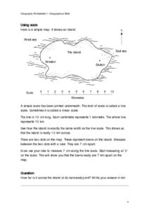
In this maps activity, learners study a simple map and the scale in kilometres. Students read the directions and answer one question. Learners then look at a sketch map of a town and answer 2 questions. Students also read how to show...
Curated OER
Map Work: How Far?
In this map scale worksheet, students analyze a map of an area with several towns marked. Students use the scale (1 cm = 1 km) to answer 6 questions about the distances between towns.
Curated OER
Scale Skills
For this mapping skills worksheet, students read an excerpt that describes three different types of scales and how to calculate distance on a map. They respond to two short answer questions using the map provided on the sheet and to...
Curated OER
Geography of South America
Student's identify geographic features of a South American map. They use the scale of the map to calculate distances between points. They identify examples of the five geographic themes on the map of South America.
Curated OER
Maps and the Pictures in Our Heads
Geographers of all ages examine different types of maps. They draw maps of their environment, utilizing both three-dimensional and picture maps. They interpret map information, noting how it can sometimes be misleading. Some good...
Curated OER
Mapping Perceptions of China
Students discuss what types of things are included on a map. They compare and contrast maps of China with a map they create and practice using different types of maps. They write analysis of their classmates maps.
Curated OER
Magical Maps
Second graders discuss the importance of using maps and how they are used. After they listen to a folktale, they develop their own story line maps and write their own folktale to accompany a map. They also identify and locate the seven...
Royal Geographical Society
An Introduction to Maps
First graders are introduced to a variety of maps such as globes, street maps, atlases, and different types of floor plans. The focus of the lesson requires individuals to create their own plan of the classroom using the PowerPoint...
Curated OER
World Projections
Students identify map projections and examine polar maps. In this map skills lesson, students use a flat world map to identify various projections and calculate the distances between locations by using a map scale.
Curated OER
Understanding Geography
Students create a map of their own neighborhood to show the relationships between the geography of the neighborhood and its economy and culture. They view and discuss an introductory video on how geographers study an area then go out...
Curated OER
Mapping the News
Students explore cartography. In this map skills and map making lesson, Students work in groups to create wall size world maps including legends, compass roses, latitude and longitude, and physical features. Students collect current...
Curated OER
Understanding: Geography
Students explore their neighborhoods. In this geography lesson, students make a map of their neighborhood. They must include a key, natural terrain, buildings and streets. They also write a descriptive paragraph about their neighborhood.
Curated OER
Introduction to Field Mapping with a Compass and Pace
Students practice using compass and calibrate their own pace, take field measurements of pre-set course with compass and pace, convert measurements into map, using angles and vectors, and make composite class map by adjusting different...
Curated OER
Using Local Geography to Make Maps
Students research, create, and present a scale representation of the county in which they live.
Curated OER
Map It!
Fourth graders demonstrate map making skills by using the computer to create maps of the geographic features, regions, and economy for their state.
Curated OER
Africa: Introduction, Geography and Mapping
Students study the geography of Africa through the use of maps. They locate, distinguish, and describe the relationships among varying regional and global patterns of geographic phenomena such as landforms, climate, and natural resources.
Curated OER
Geography With Dr. Seuss
Students read the book, The King's Stilts by Dr. Seuss and discuss the geographical information given in the book. Then they discuss and locate on a map the physical features that make up the continent of Africa. They create an original...
Curated OER
Understanding Topographic Maps
Underclassmen create a cone-shaped landform and then draw a contour map for it. Then they examine a quadrangle (which was easily located with an online search), and relate it to what they experienced. The accompanying worksheet is...


