Curated OER
One Size Fits All?
Students describe the differences between an estimate and a guess. They create reasonable estimates based on comparison and activities. Students explain how estimation is helpful in showing the relative size on a scale. They also...
Curated OER
Scale Drawings
Students discuss the importance of scaling drawings. In this math lesson, students create a scaled drawing of circuit boards. They explain why accuracy is very important when scaling.
Curated OER
Super Size It, Please!
Pupils take photos from a given distance and determine the height of the person using a scale factor. Pupils calculate the ratio of student actual height to student photo height. They take pictures from 3 different distances to see if...
Curated OER
Investigation - The Local Bagel Shop
Sixth graders investigate unit pricing to find which cup of coffee is a better buy. They use ratio and proportions to solve problems involving a change of scale in drawings, maps, recipes, etc. Students determine the unit cost of items...
Curated OER
CEENBoT Takes a Dive
Students create a map to scale using technology. In this algebra lesson, students navigate through a shipwreck to perform rescues. They use he CEENBoT program to perform the different tasks.
Curated OER
Scale
Students apply concepts of scales to solve problems. In this geometry instructional activity, students solve real world problems using scales, proportions and ratios. They predict the actual size of a model given the scale drawings.
Curated OER
Maps/ Scales and Conversions
In this math worksheet, learners look for the actual values for the measurements of distance. The answers are found on page three.
EngageNY
Informal Proofs of Properties of Dilations
Challenge the class to prove that the dilation properties always hold. The lesson develops an informal proof of the properties of dilations through a discussion. Two of the proofs are verified with each class member performing the...
Curated OER
What Is El Niño?
Students access information at remote sites using telecommunications, identify impacts by reviewing past El Ni??o events, make and use scale drawings, maps, and maps symbols to find locations and describe relationships.
Curated OER
Unit 19 Scale Drawing
In these scale drawing worksheets, students read the distance problems and select the answer from the choices. Students complete 9 problems.
EngageNY
Dilations as Transformations of the Plane
Compare and contrast the four types of transformations through constructions! Individuals are expected to construct the each of the different transformations. Although meant for a review, these examples are excellent for initial...
Inside Mathematics
Swimming Pool
Swimming is more fun with quantities. The short assessment task encompasses finding the volume of a trapezoidal prism using an understanding of quantities. Individuals make a connection to the rate of which the pool is filled with a...
Curated OER
Home on the Range
Young scholars use maps and mathematics to determine the appropriate panther population in a given area. In this Florida ecology lesson, students research the area requirements of male and female panther and use a map to help calculate...
Curated OER
Charles Lindberghs's Flight to Paris
Students practice map skills. In this map skills lesson, students locate the cities of New York and Paris on a map. Students read about the flight made by Charles Lindbergh in May 1927 from New York to Paris. Students answer 8 questions...
Edgate
Great Grids
Learners use grid boxes as a measurement tool and discover how grids are used for mapmaking and scaling down an area. They begin by attempting to draw a model shape drawn by the teacher by using the gridding process. At the conclusion of...
Mathematics Assessment Project
Linear Graphs
A line is a line is a line. As a middle school assessment task, learners first identify graphs of given linear equations. They then identify the equations that represent real-world situations.
Curated OER
Problem-Solving Decisions: Reasonable Answers
In this problem solving worksheet, students answer 6 questions pertaining to a story problem about a tabletop scale model of the Nile River.
Curated OER
Mush! Tracking Travelers on the Trail
Students get to know Alaska and the Iditarod route that is run by dogs as they track the mushers' progress on a map that they create specifically for the race. They learn about latitude, longitude, plotting on a map, checkpoints, and...
Curated OER
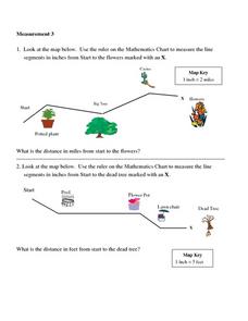
Measurement 3: Rulers
In this measurement worksheet, pupils measure the linear distance, in inches, between stated objects. Next, they determine the actual distance, in miles.
Curated OER
Mapping with a Compass: A Simulated Survey
Students use compasses and grids to map the locations of artifacts found in a simulated dig site. In groups, they role-play as future archeologists excavating a school site. Groups begin at their assigned datum and site the artifacts...
Curated OER
Geography Journey
Fourth graders examine the geographic features that define places and regions and answer questions about the state of California. They discuss the components of a map legend and answer worksheet questions using a map of California as a...
Discovery Education
Architects in Action
Hands-on and real-world applications are great ways to teach mathematical concepts. Creative thinkers examine how ratios are used to create scale models of buildings and structures. They practice working with ratios by looking at a map...
Curated OER
Real World Investigation- Math and Geography- Elevation Changes
In this math and geography real world investigation, 6th graders plan a driving trip to a city that is located several states away from their home while recording the elevations of three cities that are included in the trip. They use...
Curated OER
Location, Location
Third graders draw and interpret simple scale maps, use maps to move around efficiently or plans to propose actions. They use of a compass to specify and find directions. They display and discuss a map of the local region.


