Centers for Disease Control and Prevention
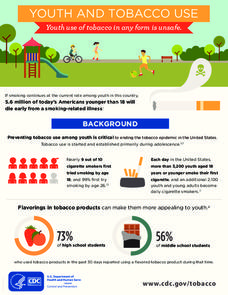
Youth and Tobacco Use
There are a number of social, emotional, and physiological reasons why teenagers start smoking, and why they continue smoking into adulthood. Help class members understand why smoking begins in youth—and how to protect themselves from...
Teaching Ideas
The Victorians Fact Cards
Want to learn some quick facts about Victorian England? Check out a series of fact cards that include information about class structure, education rights, public health, and Queen Victoria herself.
Other
Metrocosm: Your World Map Is Hiding Something
The Mercator projection is the map everyone is most familiar with, however, this map gives a distorted view of our world. Find out why and compare other map projections. Have fun clicking on the maps and changing the projections to see...
Other
National Museum of Ireland
This is the home page of the National Museum of Ireland. The museum is actually four museums: Decorative Arts and History; Country Life; Natural History; and Archaeology. You can view exhibits from each museum through this site. In...
Digital Public Library of America
Dpla: Two Hundred Years on the Erie Canal
Learn about the Erie Canal, one of the most famous man-made bodies of water in the world. Completed in 1825, the Erie Canal connected the port of New York City on the Atlantic Ocean with the Great Lakes transforming trade, industry, and...
Other
The True Size
In an effort to illustrate the spatial concepts of maps, this program provides the ability to select countries or continents and move them over others to better visualize the sizes of each of them.
Curated OER
The Works Projects Administration in Indiana
Although this site concerns itself with the WPA in Indiana, the information provides a good overall look at the Works Progress Administration in the rest of country during the New Deal era.
Other
Ifip: Information and Communications Technologies in Latin America [Pdf]
The content of a slideshow presentation on the state of computer technology integration in Latin American countries in the public and private sectors. Charts display data relating income levels with computer ownership, mobile phone use,...
Other
Irena: How to Transform Energy System and Reduce Carbon Emissions
Information about renewable energy and how the world's energy system must continue to transform in order to combat climate change. Presents statistics about what different countries are doing to use more and more renewable energy...
Curated OER
Iranian Billboard
The Iran Project examines the changes in modern Iran since 1981. This project includes a one-hour public radio documentary, "The Struggle for Iran," as well as a detailed overview of the country. Click "About Iran" to learn about this...
Curated OER
Etc: Maps Etc: United States Canal Zone Isthmus of Panama, 1912
A map from 1912 of the United States Canal Zone in Panama. The map shows the location of the canal, the deepened approaches to the canal, and the locks. The map also shows mountain ranges, railroads, projected railroads, post offices,...
Curated OER
Educational Technology Clearinghouse: Clip Art Etc: A Babylonian Map of the World
A tablet of dark brown clay, much injured, dating from the 8th or 7th century B.C. The two large concentric circles indicate the ocean, or, as it is called in the cuneiform writing between the circles, the 'Briny Flood.' Beyond the ocean...
Other popular searches
- Create a Country Project
- Country Project Rubric
- Spanish Country Project
- Research a Country Project
- Creating a Country Project
- African Country Project
- Pert Rico Country Project
- Africa Country Project
- Puerto Rico Country Project
- Country Project Power Point
- Project Country Research


