Super Teacher Worksheets
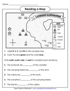
Reading a Map
Young geographers improve their map skills by practicing locating the cardinal directions on a map, identifying symbols on a map key, and describing where objects on the map are located relative to other locations.
Curated OER
State Map of Utah
In this social studies worksheet, students examine a state map of Utah and answer 7 questions, using the map as a reference. The map includes freeways and bodies of water. There is no compass rose.
Curated OER
We Found It!
First graders identify and describe landforms. They demonstrate an understanding of the compass rose and a map key using the trail of Lewis and Clark and the Corps of Discovery. They generate a map key.
Curated OER
Four Main Directions
Learners describe directions using a globe for north, east, south and west. In this mapping activity students identify the north and south pole. Learners understand the importance of the equator and the Prime Meridian. Students explain...
Curated OER
Using Four Main Directions in the Classroom
Students identify the four cardinal directions. In this map skills geography lesson, students use a magnetic compass to label the four directions in the classroom. Students use the four directions to locate objects in the classroom.
Curated OER
CLASSROOM MAPS
Pupils do a blind tour of their school by responding to verbal commands. They look and discuss various maps in the classroom. They locate the direction of the sunrise and discuss the compass directions of North, South, East, and West.
Curated OER
Ireland
In this map of Ireland worksheet, students label an Ireland map with its regions, major cities, important landmarks, compass rose and a legend.
Curated OER
Where Am I: How to Read a Map
Third graders develop an understanding of maps. They explore what a map is, who uses maps, and how to use maps. Students investigate the compas rose. They create a compose rose which illustrates the cardinal directions. Students practice...
Curated OER
Create a Compass Instructions for Teachers
Students, who are teachers, discover how to make box and water compass in their classrooms. They describe the scientific principles that are involved in making and using a compass.
Curated OER
Directions on a United States Map
Young scholars generate directions for an imaginary trip. In this map instructional activity, students review the four main directions and how to use a map legend. Young scholars locate destinations based on directions given by...
Curated OER
Determining Direction With A Map- Online Interactive
For this map skills worksheet, students analyze a city map and study the compass rose. Students answer 10 questions about the map. This is an online interactive worksheet.
Curated OER
Make Your Map
In this map making learning exercise, students make their own maps, draw symbols and place them in the map key area, and draw a compass rose to show directions for the map.
Curated OER
Describing A Place - Part I The British Isles
In this describing place worksheet, students label the cardinal and ordinal directions on a compass rose using the drop-down menus. They complete a matching activity by matching an item from column C with one in A and B. They read an...
Curated OER
Environment: Going Places
First graders learn directional words and apply this skill to map making. They record their steps on paper.
Curated OER
Geography: Japan Project Online Lesson, Part 2
Students, in small groups, create and exchange map questions and share them with students in Japan. After examining the maps, they compare and contrast the two maps on the county Web Board. Students use a rubric to evaluate their answers.
Curated OER
Learning to Read a Map
First graders identify the map and globe symbols: Cardinal Directions; Compass Rose; Mountains; Rivers; Lakes; Towns; Roads.
Curated OER
Yo Ho, Yo Ho, A Pirate's Map for Me: An Original Story
Students read Blackbeard and brainstorm their knowledge of maps. In this language arts and geography lesson, students use landmarks on their playground to review north, south, east and west and discuss the compass rose. Students read...
Curated OER
Cartography Project
A lesson involving mapping, the use of a compass, writing and following directions, and exploring the first two themes of geography is here for you. Learners create original maps that show the routes they take through their own...
Curated OER
Follow the Light
Here is another in the interesting series of lessons that use the special State Quarters as a learning tool. During this lesson, pupils learn about lighthouses, maps, the cardinal directions on a compass, and U.S. geography. There are...
Curated OER
United States Map - Lesson 9
Students explore the concept of cardinal directions. For this geography lesson, students identify the compass rose on a large U. S. map and then discuss the cardinal directions.
Curated OER
Map Creation
Second graders identify a map, symbol, key, and compass rose. Students create and print a map for teacher evaluation using the computer. Students identify the symbols on their map and orally present them to the class.
Curated OER
Map Directions and the United States
Third graders search TDC database for images of a compass rose, a miles marker, and a US map. They identify cardinal and intermediate directions to help identify their state and other states on a US map.
Curated OER
Labeling a Map of Australia
Third graders label a map of Australia. Using the internet, they research the history and maps of the continent and print a blank map. They review on how to use a compass rose and legend. In groups, they create a brochure to share...
Curated OER
Finding Your Way Using Maps and Globes
Students identify the similarities and differences between different maps and globes. Individually, they create a map of their classroom along with a compass rose. They also practice reading maps as a class and finding specific locations.
Other popular searches
- Compass Rose Worksheet
- Compass Rose Art Lessons
- Compass Rose Lesson Plans
- Using a Compass Rose
- Creating a Compass Rose
- Making a Compass Rose
- History of Compass Rose
- Using the Compass Rose
- Compass Rose Lesson
- Using Compass Rose
- Compass Rose for Directions
- Making Compass Rose


