Other
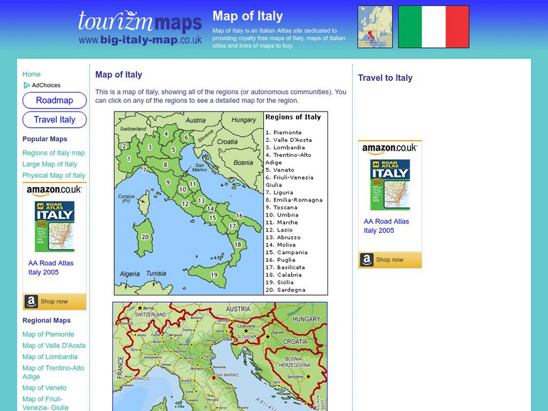
Tourizm Maps: Map of Italy
A map of Italy labeling the country's 20 different regions. Click on any region to get a full scale map of that specific area.
Other
Sacred Destinations: Cities of Italy Map
Use this interactive map of Italy to take a virtual tour of the major cities and sights found in Italy. Click on any of the hotspots to get pop-up facts and photos.
University of Texas at Austin
University of Texas: Historical Maps of Italy
Review these two maps of Italy during the Renaissance from the Perry Castaneda Collection. Zoom in to see the details of a map of the Milanese under the Visconti and one of the Republic of Florence.
United Nations
Unesco: Interactive Map of the Cities Along the Silk Roads
A map showing the locations of cities that participated in trade along the Silk Roads, stretching from Italy to Japan. Each red dot is provides information about the location and links to a UNESCO page with more in-depth information...
Franco Cavazzi
Roman empire.net: Roman Empire Map
This site from Roman-Empire.net provides an interactive map of the Roman Empire. The expanse of the empire can be viewed by dates. The site can be searched by Provinces, Territories, Tribes, Towns, Cities, or Barbarian Incursions.
University of Oregon
Mapping History: European History
Interactive and animated maps and timelines of historical events and time periods in European history from Greek and Phoenician colonization up to the 20th century.
Other
The World of Dante: Map Images
Interactive map images from Dante's "Inferno." With reproduced maps of Italy from the time of Dante's life (1300s).
BBC
Bbc History: Animated Map: The Italian Campaign
This animated map gives a good visual of the Italian Campaign which began in Sicily in 1943. Each map has a description of the action, a key is provided, and just the map animation can be replayed, or view the entire site again.
Franco Cavazzi
Roman empire.net: Roman Italy Map
This site from Roman-Empire.net is an interactive map of Roman Italy. Areas, Regions, Tribes, Towns, Cities, Rivers, Lakes, and Mountains can be searched for with pull-down menus.
W. W. Norton
W.w. Norton & Company: Map of the Unification of Italy (1850S to the 1870s)
Map showing Italian unification. Illustrated key indicates when territory was acquired.
Curated OER
Science Kids: Science Images: Map of Italy
A map featuring Italy and its neighboring countries.
Curated OER
Map of Italy
This is an online resource for information on Italy. The site includes a map and flag, government, population, languages, communications, economic summary, and a history of the country.
Curated OER
Educational Technology Clearinghouse: Maps Etc: Italy, 1914
A map of the Kingdom of Italy in 1914 subtitled "Made One Nation." This map shows the unification of Italy with dates and notations for annexation to the Kingdom of Sardinia (the founding state, which became the Kingdom of Italy in...
Curated OER
Etc: Italy During the War With Naples , 1798 1799
Map of Italy in 1799, subtitled "The War with Naples 1798-9." The map shows Italy at the time when the Kingdom of Naples briefly became the French-supported Parthenopaean Republic from January to June, 1799. The map shows the territory...
Curated OER
Educational Technology Clearinghouse: Maps Etc: Northern Italy, 1796 1797
A map of Northern Italy in 1796-1797 during the French Revolutionary Wars, subtitled "Bonaparte's Campaign." This map shows the Piedmont locations of Montenotte (1796) northeast of Nice, Dego, and Mondovi near Turin, the Po River...
Curated OER
Educational Technology Clearinghouse: Maps Etc: Italy and San Marino, 1906
A map from 1906 of Italy, San Marino, and the islands of Corsica, Sardinia, and Sicily. The map shows provinces, principal cities and towns, railroads, mountains, rivers, and coastal features. An inset map details the Bay of Naples.
Curated OER
Educational Technology Clearinghouse: Maps Etc: Italy, 1909
A map of Italy in 1909, prior to the resolution of the Italian Irredentist Movement to unite the territories of ethnic Italians. This map shows the territories of Tyrol, Istria, and Dalmatia under Austria-Hungary Empire rule, Corsica...


