Curated OER
Mapping West Virginia
Fourth graders explore West Virginia. In this Unites States geography lesson, 4th graders discuss the type of land and the cities in West Virginia. Students create two overlays, with transparencies, that show the natural land and the...
Curated OER
Holocaust Map Studies
Students analyze maps and answer discussion questions related to WWI. In this geography lesson, students analyze historic maps to determine causes and effects of WWI in Europe. Students read testimonies of Holocaust survivors and label...
Reporters Without Borders
2017 World Press Freedom Index
Freedom of the press was seen as a right so important that the Founding Fathers listed it as part of the first amendment to the United States Constitution. Americans pride themselves on this freedom, but just how free are American...
Curated OER
Mapping the Civil War
Students identify the locations of pivotal American Civil War battles. In this map skills lesson, students label Fort Sumter, Antietam, Vicksburg, Gettysburg, and the Battle for Atlanta on an outline map. The map is not included.
Curated OER
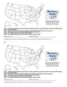
Mystery State #27
In this mystery state worksheet, learners answer five clues to identify the state in question. They then locate that state on a map.
Curated OER
Mystery State #36
In this United States mystery worksheet, students determine which state is described by the 5 clues listed on the sheet and then mark it on the outline map of the United States.
CK-12 Foundation
Regular and Irregular Polygons: Polygon States
Colorado would probably object if Wyoming enlarged its borders. Scholars use an interactive map to change the borders of U.S. states to see how angles change. They then answer questions about regular and irregular polygons.
Curated OER
Using a Political Map
In this online interactive map activity learning exercise, students examine a political map of New Jersey and respond to 9 fill in the blank questions.
Curated OER
Map Directions and the United States
Third graders search TDC database for images of a compass rose, a miles marker, and a US map. They identify cardinal and intermediate directions to help identify their state and other states on a US map.
Curated OER
Mapping World War II: During and After
In this World War II learning exercise, students follow the provided instructions to mark 2 maps according to events and outcomes of the war.
Curated OER
Describe That State
Students broaden knowledge about all the 50 states. They combine their knowledge about states with their knowledge about parts of speech to create grammatically correct sentences that describe the characteristics of the states.
Curated OER
National Expansion
Learners investigate the Manifest Denstiny. They explore how the idea was evident in 19th century American maps. Students brainstorm the relationships between maps and national expansion. They review a map from 1816 that called for...
Curated OER
What's Your Temperature?
Learners take a look at the local newspaper and focus on the weather section. They get into small groups, and each one looks at the same map, but of a different part of the country. They must prepare a presentation that shows how...
Curated OER
A Bird's Eye View of our 50 States
Third graders focus on state birds as they learned absolute location (latitude/longitude) of each state, as well as their relative location (bordering states).
K20 LEARN
Manifest Destiny: U.S. Territorial Expansion
A close examination of John Gast's painting "American Progress" launches a study of the concept of Manifest Destiny used to justify United States' policy of westward expansion. Young historians read statements from persons with different...
Curated OER
Mapping China
Students identify cities in China on a map. In this map skills instructional activity, students locate the continent of Asia and the country of China. Students use a blank map to label China and bordering countries.
Curated OER
Map Studies
Middle schoolers analyze maps of Europe, and research and discuss current wars in Europe, and compare them to World War I and World War II.
Curated OER
Mystery State #4
In this mystery state learning exercise, students answer five clues to identify the state in question. They then locate that state on a map.
Curated OER
Establishing Borders: The Expansion of the United States 1846-48
Students investigate how the United States acquired land after the Revolutionary War ended. In this establishing borders lesson, students use maps to identify territories acquired by the US and the states that later developed. Students...
Curated OER
Mystery State #18
In this mystery state worksheet, students answer five clues to identify the state in question. They then locate that state on a map.
Curated OER
Mystery State #51
For this mystery state worksheet, students answer five clues to identify the state in question. They then locate that state on a map.
Curated OER
Where in the World Is Mexico?
Students practice map-reading skills as they locate Mexico and its cities on a world map. By creating a puzzle out of a map of Mexico, students engage in a meaningful hands-on activity to help them explore that country's geography.
Curated OER
A New Federation
Young scholars describe the relationships between state and federal parliaments in Australia. They identify responsibilities shared between federal and state and territory governments. Students explore an alternative federal structure...


