Curated OER
States and Capitals Activity
Students explore states and capitals. In this U.S. geography lesson, students practice locomotor skills playing Freeze Tag. Students generate the matching capital when given a specific state name in order to continue the game.
Curated OER
Geography, Climate, and Community in the Dominican Republic
Students examine primary source materials on the Dominican Republic in an exploration of how environment influences lifestyles. They compare and contrast life in the Dominican Republic with life in the United States.
Curated OER
Places in Arkansas: A Tour of Our Unique State
A great instructional activity focuses on important cultural and historical places in the state of Arkansas. Learners are introduced to six important places in Arkansas, then create a report on a place in Arkansas. Some excellent...
Curated OER
Identifying Border States of the U.S.
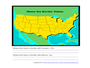
In this identifying border states of the U.S. worksheet, 3rd graders visually identify then write the names of the states that border Canada and Mexico; page 1 is a lesson, page 2 is the worksheet.
Curated OER
Tennessee State Map
For this Tennessee state geography worksheet, students color and label major cities and physical features on the map. Students also study a second map of the U.S. that shows the location of the state of Tennessee.
Curated OER
State Database Lesson
Fifth graders create a database about the geography of the United States. The access to a computer is essential for this lesson plan. The outcome is that technology is used as a tool to measure student understanding of geographical...
Curated OER
Virtual State Tour
Students research one of the fifty states in depth and create a virtual tour that showcases their research. They create a quiz to accompany their tour and then present their tour and quiz to the class.
Curated OER
The United States and Canada: Climate and Vegetation
Display U.S. and Canadian climate and vegetation through this text-companion worksheet. Learners read about the geography of these regions, take notes, and answer 3 comprehension questions as they read the selection. A graphic organizer...
Curated OER
Cities, States, Countries & Continents
In this geography worksheet, learners fill in 7 blanks with the correct geography word. Clues are given for each blank, and answers are provided.
Curated OER
Geography A to Z: The Letters W,X,Y and Z
Warm up the class with a fun geography quiz. They'll use the letters W, X, Y, and Z to answer seven geography-based questions. Y for Yangtze, Z for Zimbabwe, or Y for Yugoslavia.
Curated OER
Searching the States (or Provinces) Scavenger Hunt
Students examine information on a particular state or province. Groups of students use the internet to locate facts about an assigned state. They research information such as capital, state song, and major crops. students report their...
Curated OER
United States Map Quiz
In this online interactive geography quiz worksheet, students examine the map that includes all 50 states of the United States. Students match the names of the 50 states to the appropriate places on the map.
Curated OER
Go Maryland! Our State's Geography & Economy
Fifth graders design and create a brochure that may be used by the Maryland Department of Business and Economic Development to attract visitors in the 3 different regions of the state. In this Maryland state lesson, 5th graders research...
Curated OER
Geography Quiz 25
In this geography worksheet, students answer short answer questions about geography around the world. Students answer 23 questions about cities, rivers, countries, and more.
Student Handouts
Geography of Dr. Martin Luther King, Jr.
Young geographers follow Dr. Martin Luther King's journey during the civil rights movement by identifying major events on a map of the eastern United States, such as his birth in Atlanta, Georgia and his famous...
PBS
Arthur’s World Neighborhood: Bibliography for Kids
Support young learners as they expand their cultural awareness with this list of children's literature on countries from around the globe. Including both fictional and non-fictional texts. This resource will help...
Curated OER
European Elevation Sort
Given a prepared database of European countries, sixth graders sort the countries in ascending order by elevation and identify the five countries with the highest elevations. This cross-curricular lesson combines elements of computer...
Curated OER
What They Left Behind: Early Multi-National Influences in the United States
Students examine how the European voyages of discovery influence American culture even today. They map eighteenth century Europe's impact on the United States.
Curated OER
Getting to the Core of World and State Geography
Students create topography relief maps. In this geography skills lesson, students review geography core knowledge skills, design and make a state relief map, and compile a student atlas.
Curated OER
Guess the State?
Learners engage in a peer to peer quiz. In this state geography lesson, students ask one another questions to design a quiz that they will use to learn about their state.
Curated OER
Geography: Physical Features
Physical features in our geography are outlined in this colorful PowerPoint. First, different physical features are listed. Then, they are defined with a corresponding graphic. Tip: While presenting this slideshow to your class, ask them...
Curated OER
US Geography Crossword
In this 50 states worksheet, learners complete a crossword puzzle with facts about US geography. There are 22 words to fit in the puzzle, which has no word bank.
Curated OER
States And Shapes
Students work together and investigate the shapes of 50 states. They identify the states that they find hardest to recognize. The group then list the states in order from most difficult to just difficult to recognize and create a...
Curated OER
State Capitals- Online Interactive
In this state capitals worksheet, students learn to match the capital cities to the 50 states. Next to each name of the state, students fill in the capital city from a list that is provided. This is an online interactive worksheet.
Other popular searches
- State Political Maps
- State of Georgia Maps
- State Outline Maps
- State and Local Maps
- State Outlines Maps


