Curated OER
Etc: Maps Etc: The Peaks and Volcanoes Which Form the Andes, 1873
An orographic sketch map from 1873 of the Andes mountain chains. The map divides the system into the Andes of Columbia and Ecuador, Andes of Bolivia and Peru, Andes of Chile, and Andes of Patagonia. The map is keyed to show the prominent...
Curated OER
Ana Mar
Excellent article about the oil economy in Latin America. Learn about the impact of oil on the economies of Ecuador, Venezuela, and Peru.
Curated OER
Machiguenga Indians Inspect the 'Right of Way' Cleared for Natural Gas Pipeline
Excellent article about the oil economy in Latin America. Learn about the impact of oil on the economies of Ecuador, Venezuela, and Peru.
Curated OER
World Info Zone: Galapagos Islands
Featured is an overview of the geography, environment, and history of the Galapagos Islands which are a province of Ecuador. Includes photographs.
Curated OER
World Info Zone: Galapagos Islands
Featured is an overview of the geography, environment, and history of the Galapagos Islands which are a province of Ecuador. Includes photographs.
Curated OER
Organization of American States:simon Bolivar
An informative exploration of the life of Simon Bolivar, the man known in South America as the "Liberator," because he led revolutions against Spanish colonial overlords in Venezuela, Ecuador, Peru, and Colombia.
Study Languages
Study Spanish: La Llama
This site has an explanation in Spanish and English with a few comprehension questions about the llama in the Andes area of South America. Additional links are provided for more information on this unique animal. Great reading selection...
Wikimedia
Wikipedia: Pacific Ring of Fire
Wikipedia offers information on the location of the Pacific Ring of Fire, an area of frequent earthquakes and volcanic eruptions. Map included.
Other
News Central: South America
A collection of links to newspapers from various countries in South America. Most are in the native language.
World Atlas
World Atlas: South America
Presents a description of the geography of South America, the 4th largest continent, with maps and photos.
Curated OER
Perry Castaneda Map Collection: Latin America Map
This political map of Latin America and South America is in color and features major cities.
Colby College
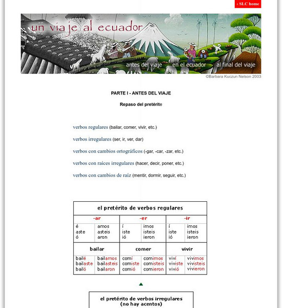
Spanish Language & Culture: Antes Del Viaje (Peterite Tense)
This review of regular and irregular Spanish verbs features charts for the preterite tense, including stem-changers and spelling changes.
Curated OER
Clip Art by Phillip Martin: Flamingo, Wings Splayed
Cartoon flamingo flapping its wings.
Curated OER
Clip Art by Phillip Martin: Sea Lion
A clipart illustration by Phillip Martin titled "Sea Lion."
Curated OER
Clip Art by Phillip Martin: Pelican
A clipart illustration by Phillip Martin titled "Pelican."
Curated OER
Clip Art by Phillip Martin: Tortoise
Cartoon illustration of the Galapagos giant tortoise.
Curated OER
Clip Art by Phillip Martin: Blue Footed Booby
A clipart illustration by Phillip Martin titled "Blue Footed Booby."
Other popular searches
- Ecuadorian Rainforest
- Ecuador Rain Forest
- Ecuador Rainforest
- Ecuadorian Rain Forest
- Cultures Ecuador
- Ecuador Homework
- Ecuador Dances
- History of Ecuador
- Ecuador ,.South America
- Chachi People of Ecuador
- Ecuador Folktales
- Ecuador Lesson Plan


