Hi, what do you want to do?
Curated OER
Scaling it Down: Caves Have Maps, Too
Measurement and map skills are the focus of this lesson, where young scholars crawl through a "cave" made out of boxes, desks and chairs, observing the dimensions. Your young geographers measure various aspects of the cave and...
Curated OER
Mapping
Introduce middle or high schoolers to topographic maps with this PowerPoint. After a review of longitude and latitude, display and describe contour lines and intervals. Also explain map scale. This is a useful presentation for a social...
Curated OER
Maps Reinforcement
In this map worksheet, learners complete 6 multiple choice questions and 5 short answer questions about 3 different map figures.
Curated OER
Right Place, Right Time
Fourth graders complete mathematical word problems. They study the relationships among distance, speed, and time; and measure travel distances. They measure distances using a piece of string and a ruler and practice converting several...
Curated OER
Tracking Satellites Using Latitude and Longitude
Students, viewing an Internet site, plot the path of several satellites using latitude and longitude over the course of an hour. They learn the four basic types of satellites and their purpose.
Curated OER
Map Scale
Third and fourth graders are introduced to the concept of map scale. Using an illustration, they discuss if it shows the actual size of the object and why scale is used to represent areas. They use some items in the illustration to...
Curated OER
The Gold Rush
Students identify the routes involved in the Gold Rush on a map. In this map skills instructional activity, students use a United States map to locate the routes used to travel to California during the Gold Rush. Students demonstrate how...
Curated OER
Cattle Trails
Students identify and locate cattle trails on a globe. In this map skill lesson plan, students use a marker to locate Texas and Montana and use the map scale to calculate the distance of the cattle trail.
Curated OER
Exploration of Scale Models
Students consider the concept of scale models. In this scale lesson, students compare the sizes of various every day toys to the sizes of the larger objects they represent.
Curated OER
Lesson Nine: Size and Scale
Students investigate scale as it is related to maps. In this map lesson, students read Jack and the Beanstalk by Carol North. Students then compare the setting in the story to a landscape picture map to help them study scale.
Curated OER
Map Work: How Far?
For this map scale worksheet, students analyze a map of an area with several towns marked. Students use the scale (1 cm = 1 km) to answer 6 questions about the distances between towns.
Curated OER
Geographical Skills-- Map Scale
In this maps learning exercise, learners study a simple map and the scale in kilometres. Students read the directions and answer one question. Learners then look at a sketch map of a town and answer 2 questions. Students also read how to...
Curated OER
Exploring Earth Through Maps and Technology
In this maps activity, students read 3 pages of detailed information about maps, latitude, longitude, topography, satellites and global positioning. Students then answer 10 questions. There is also a research project assignment available.
Curated OER
Map Making/Floor Plans/Map Reading
Students apply their knowledge of scale when mapping the classroom. They determine the use of a map legend and orient a map using a compass. They create the classroom maps using transfer graph paper.
Curated OER
Map Scale and the Pioneer Journey
Fourth graders, using a map, ruler and calculator, determine the distance the pioneers traveled from Nauvoo, Ill. to the Salt Lake Valley.
Curated OER
Are We There Yet?
Pupils discover how to use maps and why they are important when using a map. They calculate distance using a map scale and time using travel speed and a map scale.
Curated OER
Map Scaling
Second graders use a map scale to determine distances between cities in the state of Florida.
Curated OER
How Far Away
Students investigate how a historic map drawn in the early days of interstate automobile travel represented distances. They measure distance within their personal space.
Curated OER
Plan a Cruise Lesson Plan
Students measure distances and report them in fractions, convert fractions to decimals, and multiply decimals.
Curated OER
Where Is Japan? How Far Is That?
First graders use literature and hands-on activities with maps and globes to explain distance and tools used to measure distance. They select tools to measure various objects in the classroom, then apply those concepts to their map...
National Geographic
National Geographic: Measuring Distances on a Map
Activities will enhance students' understanding of how to read the map scale and apply it to measuring distances between locations.
TeachEngineering
Teach Engineering: Scaling the Map
Students learn how to determine map distances and areas using the map scale. They get a feel for how much an area represents on the map in relation to the size they are suggesting for their underground caverns to shelter the Alabraska...
Houghton Mifflin Harcourt
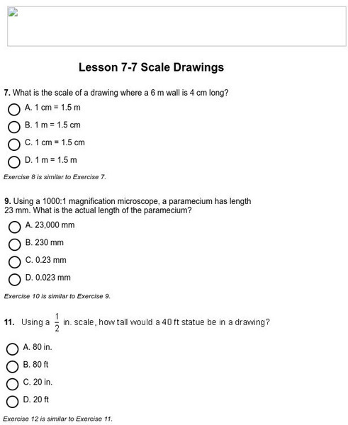
Holt, Rinehart and Winston: Homework Help Independent Practice: Scale Drawings
Get independent practice working with scale drawings. Each incorrect response gets a text box explanation and another try. Correct responses are confirmed.


