Curated OER
South America Map
In this South American political map worksheet, students examine both national boundaries and national capitals.
Curated OER
Americas: Political Map
In this North America and South America outline map learning exercise, students examine the political boundaries of the 2 continents.
Curated OER
Europe: Political Map
In this Europe political map worksheet, students examine each country's boundaries. The map also highlights each of the nation's capitals with a star.
Curated OER
South America Map
In this South America political map learning exercise, students examine the country boundaries. The map also labels each of the countries and their capitals.
Curated OER
Europe Labeled Map
In this Europe political map worksheet, students examine the national boundaries. The map also highlights each of the nation's capitals with a star. The countries and capital cities in this map are labeled.
Curated OER
Europe at Exploration 1500
In this world empires and trade in 1500 worksheet, learners examine a world empire map, world trade map, and Europe map. All maps display information from 1500.
Curated OER
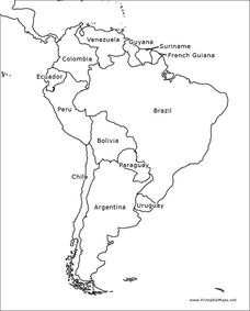
South America Outline Map
In this blank outline map learning exercise, students explore the political boundaries of South America and the nations there. This map may be used in a variety of classroom activities. The map is labeled with the country names.
Curated OER
South America Outline Map
In this blank outline map learning exercise, students explore the political boundaries of South America and the nations there. This map may be used in a variety of classroom activities. The location of the capital cities are...
Curated OER
European Country Map
For this Europe political map worksheet, students examine the national boundaries. The country names are labeled on the map.
Curated OER
Europe Outline Map (Labled)
In this blank outline map learning exercise, students study the political boundaries of the labeled European nations.
Curated OER
Australia Map
In this blank outline map instructional activity, students explore the political boundaries of Australia. This map is labeled and may be used in a variety of classroom activities.
Curated OER
Australia Map: Labeled
In this Australia outline map worksheet, students make note of the political divisions of the 5 provinces and territories of the nation. This map is labeled.
Curated OER
Australia Map: Labeled
For this blank outline map worksheet, students explore the political boundaries of Australia and its provinces and territories. This map is labeled and may be used in a variety of classroom activities.
Curated OER
Silk Road Caravan
Students determine how the geographic features of the Silk Road trade route contributed to the economic development and diffusion of culture in both Eastern and Western Civilizations.
Curated OER
The Fabric of Our World
Students discuss cultural diversity, and examine how the community reflects the cultural background of the inhabitants. They read the book, People, take a community walk, create a rainbow chart, and research other states for relocation...
Curated OER
The Mysteries of El Nino: How Much do We Really Know?
Seventh graders investigate the causes and effects of El Nino and explore its global impact on weather related occurrences through this series of activities.
Curated OER
Human Impacts on Major Rivers of the World
Learners explore motivations behind human intervention in the stream flow of selected rivers, infer kinds of interventions and their results, and evaluate level of success of such interventions of stream flow as well as environmental...
Curated OER
Time For Change
Students examine and discuss the inventions and changes created by the Industrial Revolution. They create posters or clay models about inventions, write paragraphs about the advantages and disadvantages of the changes, and develop a...
Curated OER
Rain Forests: A Disappearing Act?
Students examine and locate rainforests on maps, and research the patterns of their destruction. They develop a bar graph of rainfall and temperature data, write a journal entry, and research the people, animals, and plants/products of...
Curated OER
The Tennessee River: The Tie That Binds
Seventh graders examine the Tennessee River to see why it is still a major transportation artery in lieu of the age of modern transportation such as interstate highways, air cargo, and elaborate railway systems.
Curated OER
Three Gorges Dam: Will China Sink or Swim?
Seventh graders study the Three Gorges Dam, which is the largest dam built in the world. They examine how the dam impacts China as it prepares for the 21st century.
Curated OER
Air Pollution in Mexico City
A fantastic lesson on urban air pollution problems throughout the world is here for you. Learners understand that there are many factors involved in creating pollution, that there are many health effects brought on by air pollution, and...
Curated OER
Itaipu Dam and Power Plant (Brazil and Paraguay)
Learners study South America's Itaipu Dam and Power Plant in order to gain an understanding that hydroelectric power is a major means of generating electricity throughout the world. They also look into the environmental impacts that...
Curated OER
The Republic of Sakha (Yukutia)
Young geographers learn about the extreme temperatures found in the Rebublic of Sakha, and study the hardships caused by these temperatures. They look at why people choose to live in such a remote and rugged area. This incredible,...
Other popular searches
- Five Themes of Geography
- U.s. Geography
- China Geography
- Africa Geography
- Mexico Geography
- Canada Geography
- Asia Geography
- France Geography
- Japan Geography
- World Map
- Ireland Geography
- Geography Studies


