Free Management Library
Map: Key Concepts in Design of Organization
Defines organizational design and describes the key concepts. Provides links to more information.
ClassFlow
Class Flow: Map Key
[Free Registration/Login Required] This flipchart introduces the purpose of a map, map symbols, and the map key or legend. Activote questions reinforce the concepts.
Other
The Silk Road Yesterday and Today: Map Assignment
Assignment from virtual learning module in which students label a map of the Silk Road route with physical features, then take a virtual tour to research goods, artifacts and ideas traded along the way. Students also complete a graphic...
SMART Technologies
Smart: Geography Unit: Maps
This geography unit is designed to follow the 1st Grade geography skills required in Virginia. Students are expected to use cardinal directions, read map keys and understand map symbols, as well as identify our city and capital.
US Geological Survey
Usgs: Geologic Maps
This site has a good description of what this particular type of map represents. It also explains the colors and letter symbols, faults, and strike and dips.
ClassFlow
Class Flow: Parts of a Map
[Free Registration/Login Required] This flipchart explores the basic parts of a map including the map title, compass rose and map legend.
Read Works
Read Works: Learn About Maps
[Free Registration/Login Required] Intended to support early elementary students' reading comprehension, the basic terminology associated with map are explained in this informational text. A question sheet is available to help students...
US Holocaust Memorial Museum
U.s. Holocaust Memorial Museum: Holocaust History Animated Maps
To fully understand the breadth and scope of the Holocaust, view the following maps of key locations. These maps are in video form with explanations provided. There are also links provided for further research.
Curated OER
U. Of Texas: Yemen: Distribution of Ethnoreligious Groups and Key Tribal Areas
An interesting map showing the distribution of the major religious groups, the tribal areas, and pie graphs showing the percentages of ethnic groups and religious sects. From the Perry-Castaneda Collection.
PBS
Pbs Learning Media: Gorongosa Interactive Map | Hhmi Bio Interactive
This interactive map of Gorongosa National Park in Mozambique allows users to explore different features of the park, including key components of the conservation strategy.
Science Buddies
Science Buddies: Interpreting Area Data From Maps vs. Graphs
Graphical methods of data presentation are a key feature of scientific communication. This project asks the question, "What's the best way to compare the land area of states: a map or a bar graph?" You'll be measuring performance on two...
Louisiana Department of Education
Louisiana Doe: Louisiana Believes: Social Studies: Grade 1: Using Maps
First graders develop and express claims through discussions and writing in which they explore and create maps using map keys, and map symbols. Students engage with the sources to build their map skills.
Annenberg Foundation
Annenberg Learner: United States History Map: From Sea to Shining Sea
A great interactive map that reinforces your knowledge of the geographic features of the United States. Begin by reading general information on reading maps, then play the game.
Texas Instruments
Texas Instruments: Map It!
In this activity, students explore map making. Students' read a story, identify the locations of different places in the story, decide the distance between each set of places in the story, and create a map with a legend.
ClassFlow
Class Flow: Introduction to Maps
[Free Registration/Login Required] Students are expected to: explain the purpose of a map; identify and use a compass rose; use a grid to locate objects on maps; and use a map key. Activities are hands-on with students manipulating...
Soft Schools
Soft Schools: Geography/map Skills Quiz
In this ten question quiz, students can assess their understanding of key geographical features on maps.
University of North Carolina
Unc University Libraries: Digital Collections: Gilmer Civil War Map Collection
A large collection of Civil War maps of the south, mostly North Carolina and Virginia. The collection can be searched by state or key word.
Other
Reading Quest: Strategies for Reading Comp.: History Frames: Story Maps
This activity will help you teach students chronological order as well as identifying key people and events. Printable worksheets.
Enchanted Learning
Enchanted Learning: Pennsylvania: Facts, Map, and State Symbols
A list of key facts about the state of Pennsylvania, including information about Pennsylvania's state symbols. Useful extras for teachers include black-line masters of concept diagrams, maps, and thought organizers.
BBC
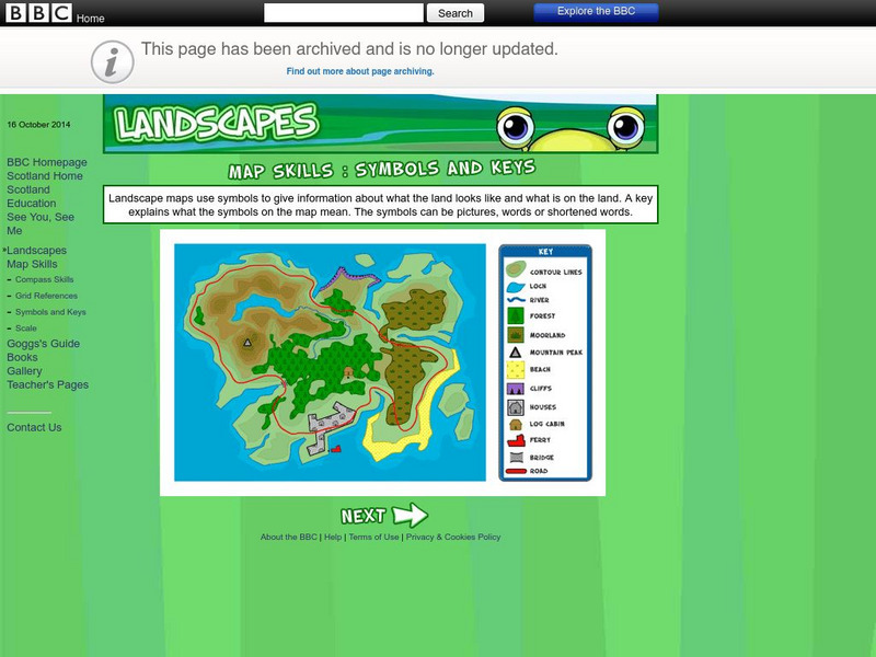
Bbc: Landscapes: Map Skills: Symbols and Keys
A guide for young learners to understand reading maps and their keys.
Better Lesson
Better Lesson: Character Web
In this instructional activity, young scholars will create a character web. Students will use a character from their storybook character for the web.
PBS
Pbs Learning Media: Elections 1896 & 1900: Interactive Map: Biography of America
This interactive map and video from A Biography of America will help compare how key issues in the elections of 1896 and 1900 influenced geographical patterns in both presidential and congressional election results. Although the...
Library of Congress
Loc: World War Ii Military Situation Maps
Interactive timeline with audio feature depicts the key events of "The Battle of the Bulge" which took place in northern France beginning December 16, 1944 to January 18, 1945 as told through the daily situation maps made for the US...
Other
Islam Project: Maps
A series of historical and near-present-day maps that span Islamic history. Starting with A.D. 750, the maps illustrate both the spread of Islam (from Medina outward to Africa, the Middle East, Europe, and other parts of the world) and...
Other popular searches
- Map Key and Legend
- Map Legends
- Map Key Legend
- Map Keys and Legends
- Map Key Legend Activities
- Map Legends and Symbols
- Map Legends First Grade
- Interpreting Map Legends
- Reading Map Legends
- Creating Map Legends
- Using Map Legends
- Semantic Map Legends


