Curated OER
Exploring the Natural World of the Balkan Peninsula
Students explore the different habitats in the Balkan peninsula. In this ecology instructional activity, students research about a species and create a 3D diorama of its environment. They present project in class and share their research...
Curated OER
Sanctuary: Quail Island Banks Peninsula
Students explore world geography by creating a 3D diorama. In this New Zealand land form lesson plan, students examine color images of New Zealand's wildlife and discuss the different elements inside them. Students utilize these images...
Curated OER
Things That Stick Out Or: How To Find Your Way Around on a Map
Students explain the meaning of and recognize the map outlines of a peninsula, an isthmus, and a cape.
Stanford University
Arabian Peninsula
How do cultural differences affect our view of history? The assessment geared towards high school historians, focuses on the credibility of primary sources. Young academics analyze a text and complete short answer questions to determine...
Curated OER
Species Interactions in the Yucatan Peninsula
Sixth graders explore how organisms interact with one another other in their environment. For this organism lesson, 6th graders understand abiotic factors and or biotic components of their environment. Students decide if the interactions...
Curated OER
Mexico
Before sending your students off to complete their own research on Mexico, introduce them with this ten-slide PowerPoint. It is filled with interesting facts and colored photos of Mexico. Tip: Assign your class different aspect or cities...
Curated OER
Geographic Landforms
Each slide is a simple notebook page with one landform in blue and its definition in red. There are 26 vocabulary terms in all, some you may want to use, and others easily hidden. It is recommended that you add photos or other graphic...
Curated OER
Arabia: Educator's Resource and Activity Guide
MacGillivray Freeman's film Arabia presents viewers with remarkable images and insights into this ancient and mysterious land. An educator's guide is designed to provided teachers with the materials they need to support a showing of the...
Curated OER
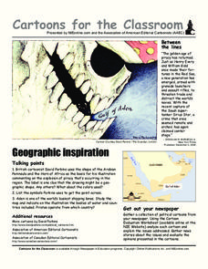
Cartoons for the Classroom: Geographic Inspiration
A wonderfully graphic cartoon entices learners to read more about issues near the Arabian Peninsula. They will use the provided cartoon and critical thinking question to practice building their analytical and critical thinking skills....
Curated OER
Discovering the Past Using the Future: Remote Sensing and the Lost City of Ubar
Students identify and locate specific locations on the Arabian Peninsula, the Rub al Khali Desert, and present day Oman. They identify other names for the lost city of Arabia as Ubar, the Atlantis of the Sands, Iran, and the city of towers.
Curated OER
Northwest Connections
Learners compare and contrast where they live in Hawaii to the Makah Indian Reservation in Neah Bay, Washington on the Olympic Peninsula, then make a Venn Diagram after hearing two stories dealing with the Trickster type characters of...
Curated OER
Interdependency
In this interdependency worksheet, middle schoolers respond to 6 short answer questions about water resource sharing after they read assigned textbook pages.
Curated OER
Michigan
In this Michigan worksheet, students respond to 7 questions that are related to the state of Michigan. First, they identify and name the state's capital and when it became a state. Then, students identify and name the state's motto,...
Curated OER
Sanctuary: Quail Island Banks Peninsula
Students consider the connection between the past and future landscape of Quail Island. In this visual arts lesson, students observe existing artwork, art vocabulary, and connections to the role of social sciences when painting...
Parkwood Hill Intermediate
Map Skills Project
Young pupils develop their mapping skills and knowledge by designing their own islands, using geographic terms and physical features they have learned as features of their work.
Curated OER
The Geography & Peoples of Europe
Extremely throrough and informative, this presentation details many aspects of European geography and demographics, including natural resources, climate, topography, and population distribution. This slideshow would be an excellent...
Curated OER
The Earth's BIG Features
Your students will enjoy the vivid pictures and interesting facts about world geography, in this presentation. Depicted are several major geographical features found around the world and a description of each.
Space Awareness
Navigating with the Kamal
Historians have proven that as early as 1497 skilled navigators were using a kamal to sail across oceans. Scholars learn about navigation tools and astronomy before building their own kamals. They then learn how to use it to determine...
Curated OER
Greek Geography
A riddle and a class lecture kick off this lesson on Greek Geography and city features. Learners use a worksheet to answer questions related to what they learned in lecture and complete a homework assignment. Note: This is a lesson...
University of California
Interactions in Baghdad and the Abbasid Caliphate
An interesting resource focuses on the cultures of different peoples that have lived in Baghdad and their interactions. Academics view 11 sources to understand how Baghdad has been home to people of many faiths and cultures throughout...
Curated OER
Where is Mesoamerica?
Students create a map of Mesoamerica using construction paper, clay or by drawing it. In this World Geography lesson, students determine the location of Mesoamerica, make a map, then present their map to their class.
Curated OER
Landscape Picture Map: Natural Features
Learners discover six landscapes. In this natural features lesson, students review the meaning and examples of natural features. Learners use a landscape picture map to identify six natural features.
Curated OER
Geography
Third graders study the Mediterranean Region by locating and identifying Italy, Greece, France, Spain, North Africa, the Mediterranean and Adriatic Seas.
Curated OER
Resource Pack: Quail Island Banks Peninsula
Students look at birds that no long exist on Quail Island, those that currently are there, and ones that may be reintroduced. In this birds lesson plan, students put the birds into categories.
Other popular searches
- Arabian Peninsula
- Arabian Peninsula Map
- Arabian Peninsula History
- Arabian Peninsula Geography
- Arabian Peninsula Culture
- Iberian Peninsula
- Blank Map Iberian Peninsula
- Arabian Peninsula Desert
- The Arabian Peninsula
- Scandinavian Peninsula
- Pictures Arabian Peninsula
- Arabian Peninsula Government


