Curated OER
World Map and Globe - Lesson 15 (K-3)
Young scholars discover mountain ranges and their locations in the world. In this physical map lesson plan, students locate and identify major mountain ranges of the world on a large physical map.
Curated OER
Natural Features
Learners identify natural features on a map. In this geography lesson, students identify six physical features and create pictorial definitions for each term. The terms which are listed in this lesson are mountain, hill, island, river,...
Curated OER
World Map and Globe - Lesson 15 Mountains of the World
Students locate major world mountain ranges. In this geography activity, students identify major mountain ranges on 6 on of the 7 continents on a large world physical map.
Curated OER
The Mountain Environment - Avalanche!
In this environment worksheet, students draw picture that illustrate an avalanche adventure. They draw a free snowfall on a mountain, the engine that is vibrating, the avalanche that traps men, and fill in speech bubbles that tell how...
Curated OER
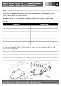
The Mountain Environment - Visitors and the Environment
In this geography and environment worksheet, students describe the advantages and disadvantages of having visitors in the mountains during the summer. They tell about how the environment is managed in the area that they live in.
Curated OER
Alaska
In this Alaska state worksheet, students research and respond to various questions related to the state of Alaska. They identify and name the state's capital and statehood. Then, students identify and name the motto, bird, flower, and...
Curated OER
Montana
In this Montana worksheet, students respond to 7 questions that are related to the state of Montana. First, they identify and name the state's capital and when it became a state. Then, students identify and name the state's motto, bird,...
Curated OER
California
In this California instructional activity, students respond to 7 questions that are related to the state of California. First, they identify and name the state's capital and when it became a state. Then, students identify and name the...
Curated OER
Colorado
In this Colorado worksheet, students respond to 7 questions that are related to the state of Colorado. First, they identify and name the state's capital and when it became a state. Then, students identify and name the state's motto,...
Curated OER
What is Climate?
In this weather learning exercise, students identify and explain the factors that can affect the climate in each area of the illustrated map. Then they describe the various effects of these factors, such as air pressure systems and the...
Curated OER
Mountain Puzzle
In this mountain puzzle, students identify famous mountain ranges. Examples include Blue Ridge, Smokies, and Rockies. A list of 15 mountains and mountain ranges are provided to assist students in their search.
Curated OER
Australian Landforms
In this geography worksheet, students identify the various landforms of Australia. They use an atlas to draw in and color these various landforms on the given blank map of Australia.
Curated OER
Everest Word Search
In this social studies learning exercise, students find the words about Mt. Everest and the answers are found by clicking the button at the bottom of the page.
Curated OER
Extreme Elevations
For this geography worksheet, 5th graders work in groups in order to locate and graph mountains found on all the continents of planet earth.
Curated OER
Water, Rivers & Topography
Students explore the topography of Idaho and the importance of surface water and drainage. using digital maps, they inspect the courses of major rivers, Yellowstone Hot Spots, and the natural landscaping of Pocatello. Students explore...
Curated OER
Delightful Directions
First graders identify and demonstrate how symbols and models are used to represent features of the environment. They identify the directions on a map as east, west, north, and south. Finally, 1st graders play a direction game, move to...
Curated OER
Climb a Mountain, Raft a River on Your Own Land
Students are introduced to the characteristics of a map. As a class, they discuss the uses of public lands in their community and develop symbols for each feature. They use the symbols to create a map showing the recreational uses of...
Curated OER
Landform Tag
Third graders explore various landforms. They play landform tag while exploring the various types of landforms that are found within the United States. Students locate landforms as they are called by the teacher.
Curated OER
Earth Movers
Students read an online article about an earthquake and follow up with a series of discussion questions about earthquakes. They answer questions in their science journals about continental drift, plate tetonics, and their influence on...
Curated OER
Mountain Building
Teacher prepares four layers of Plasticine stacking layers on top of each other to create a model of how rocks within the earth can be folded creating anticlines and synclines below the surface and mountains and valleys on the surface.
Curated OER
The Earth's Crust
Students use clay to form models of the different landforms and then complete a data table using a map, atlas, or the Internet to locate famous landforms in the United States. Students complete various activities, writing down their...
Curated OER
Key Figures of the 1899 Harriman Alaska Expedition
Students gain general knowledge of the goals, route, participants, and significance of the 1899 Harriman Expedition. They link names of glaciers, fiords, mountains, flora and fauna with names of the 1899 Harriman Expedition...
Curated OER
Sea to Sky
Students investigate the Earth's major landforms and how they occur, and how engineers apply this knowledge for the design of transportation systems, mining, and measuring natural hazards. They listen to a teacher-led lecture, match...
Alabama Learning Exchange
Forces that Change the Land
Students conduct Internet research find information about the following landforms: mountains, canyons, and valleys. They create travel brochures of their findings.


