Oregon State
World Map of Plate Boundaries
Young geologists piece together the puzzle of plate tectonics in an earth science lesson. Given a physical map of the world, they search for land formations that indicate the location of different types of plate boundaries.
Institute of Electrical and Electronics Engineers
Shake it up with Seismographs!
Shake things up in your STEM or earth science classroom when you have small groups construct their own seismographs. A reading assignment on the history of seismographs, the Richter scale, and current technology sets the stage for the...
California Academy of Science
Earthquakes and Tectonic Plates
Here is a comprehensive package in which middle schoolers learn about types of seismic waves, triangulation, and tectonic plate boundaries. Complete vocabulary, colorful maps, and a worksheet are included via links on the webpage. You...
Scholastic
Study Jams! Earthquakes
Have a seismic moment with your class as you show this animated video on earthquakes. Viewers find that quakes occur on faults and are caused by shifting of continental plates. They learn what properties are studied by seismologists and...
Curated OER
Earthquakes and Volcanoes
Even though volcanoes look alike, they can be very different based on the types of lava that erupts from their surface. Learn about strata volcanoes, shield volcanoes, and the varying viscosity of lava with an engaging hands-on activity....
Curated OER
Building for the Big One
Learners build and test structures that can best withstand earthquakes. They create their structures from playdough, cornstarch, grape-nuts and popsicle sticks and place their structures on a "shake table."
Curated OER
Plate Tectonics - Evolution of the Earth
Tons of photographs, diagrams, animations, and satellite images fill the slides of an education earth science presentation. It begins with volcanic activity and earthquakes, and then moves into plate tectonics, boundaries, and driving...
Curated OER
The Biggest Plates on Earth
The best part about teaching guides is all the great information you can use to inform your class. They infer what type of boundary exists between two tectonic plates. Then, using given information on earthquakes and volcanism they'll...
Curated OER
Earthquake Detector
Students investigate earthquakes and describe the interactions inside the Earth that cause them to occur. Then they research the equipment and systems for detection and measurement of earthquakes. Students also build and engage in a...
Curated OER
Good Old Earth Materials
Young scholars investigate different types of building structures and how they are able to stand up to earthquakes. Through comparison they determine which buildings are better able to handle earthquakes than others. They create a...
Curated OER
Earthquake Strikes Virginia
In August of 2011 an earthquake shook the nation's capitol, and became a newsworthy event; learners read this New York Times article to find out why. They read the piece then answer nine related comprehension questions. Two additional...
Curated OER
Plotting Earthquakes
Students plot earthquakes on a map. In this lesson on earthquakes, students will explore recent earthquake activity in California and Nevada. Students will plot fault lines and earthquake occurrences on a map.
Curated OER
USGS Seismometer
A large black-line diagram of a seismometer fills this page. It is not a worksheet, but rather an explanation of how a seismometer works. You could make a transparency of it or display it via a video screen when teaching about seismic...
Curated OER
Volcanic Environments
A diagram showing a cross-section of Earth points out the location of different plate boundaries and displays the numbers one through five. Beneath the diagram are five photos of different types of volcanoes. The object of the activity...
Curated OER
Erupting Volcanoes!
Students examine the causes of earthquakes, volcanoes, and floods, and explore how these events shape the surface of the earth. In this erupting volcanoes instructional activity, students create a volcano model of their own, make...
Curated OER
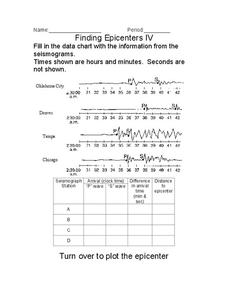
Finding Epicenters
In this earthquake learning exercise, students use the seismographs from different locations to determine the epicenter for the earthquake. Students plot the epicenter on a map. This learning exercise has 1 graphic organizer.
Curated OER
Devastation of Indian Quake
Students read an online article at CNNfyi.com to determine what happened in India after an earthquake. They determine the magnitude of this earthquake and address the issue of relief efforts from other countries.
Curated OER
Cartoons for the Classroom: Earthquake in Haiti
Trying to expand your scholars' perspectives to think globally? Use this critical-analysis handout. A poignant political cartoon points out the devastation required to get U.S. attention focused on helping Haiti. Background information...
Curated OER
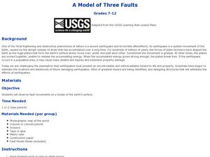
A Model of Three Faults
Students observe fault movements on model of the Earth's surface, find fault movements associated with different types of plate boundaries, research examples of non-plate boundary faults, and research and report on the types of faults...
Curated OER
Current Earthquake Activity
Fifth graders record any earthquake activity throughout the school year on various maps. In groups, they identify a map locating the points given to them by their teacher. To end the lesson, they add the date, strength and damage to each...
Curated OER
Evaluating an Illinois Earthquake
Young scholars develop awareness of occurrences of earthquakes in Illinois and their past and potential future damage, and examine distribution of earthquakes in central U.S. regions.
Curated OER
Stressed Out!
Have your class engage in lessons on earthquakes. Learners explore the science behind earthquakes using interactive websites and video clips. Then, they review the layers and parts of the Earth before delving into the causes of...
Curated OER
Natural Disaster
Describe how plate tectonics account for various land formations. Learners discuss different marine sanctuaries and create a poster about tectonic activity in these areas. They share their posters with the class.
Curated OER
Forces of Nature: Ring of Fire
Third graders will research the Ring of Fire and be able to share their findings with their partner. They will also demonstrate volcanic eruptions using a baking soda and vinegar volcano model. Then they will discover how continental...


